Museums & Culture
The 1755 Lisbon Earthquake: How It Shaped the City You See Today
The devastating 1755 earthquake that destroyed Lisbon and how the Marquês de Pombal rebuilt it—an essential story for understanding modern Lisbon.
In this guide
- What Happened on 1 November 1755
- The Death Toll
- Buildings and Treasures Destroyed
- The Marquês de Pombal
- The Reconstruction Plan
- The Earthquake’s Impact on Western Thought
- What You Can See of the 1755 Earthquake Today
- Why Some Buildings Survived and Others Didn’t
- Lessons for Modern Lisbon
- Earthquake Walking Tour (Self-Guided)
- Other Earthquake Sites in Portugal
- Books and Films
- FAQ: 1755 Lisbon Earthquake
- Bottom Line
The 1755 Lisbon earthquake wasn’t just one of history’s deadliest natural disasters — it was a turning point in European thought, urban planning, and the birth of modern seismology. On 1 November 1755 — All Saints’ Day, at around 9:40 AM — a massive earthquake struck off the Atlantic coast, followed roughly 40 minutes later by a devastating tsunami and then fires that burned for six days. Together they destroyed 85% of Lisbon and killed a number of people historians estimate anywhere from 12,000 to over 50,000 in Lisbon alone, depending on source and methodology. Voltaire’s Candide, modern building codes, and the entire grid of central Lisbon today are direct consequences.
If you want the story told immersively rather than read, Belém now has a whole attraction devoted to it — our Quake museum guide covers what it is, what it costs and who should skip it.
One piece of infrastructure came through 1 November 1755 entirely undamaged and kept supplying the ruined city with water — see our Lisbon aqueduct guide.
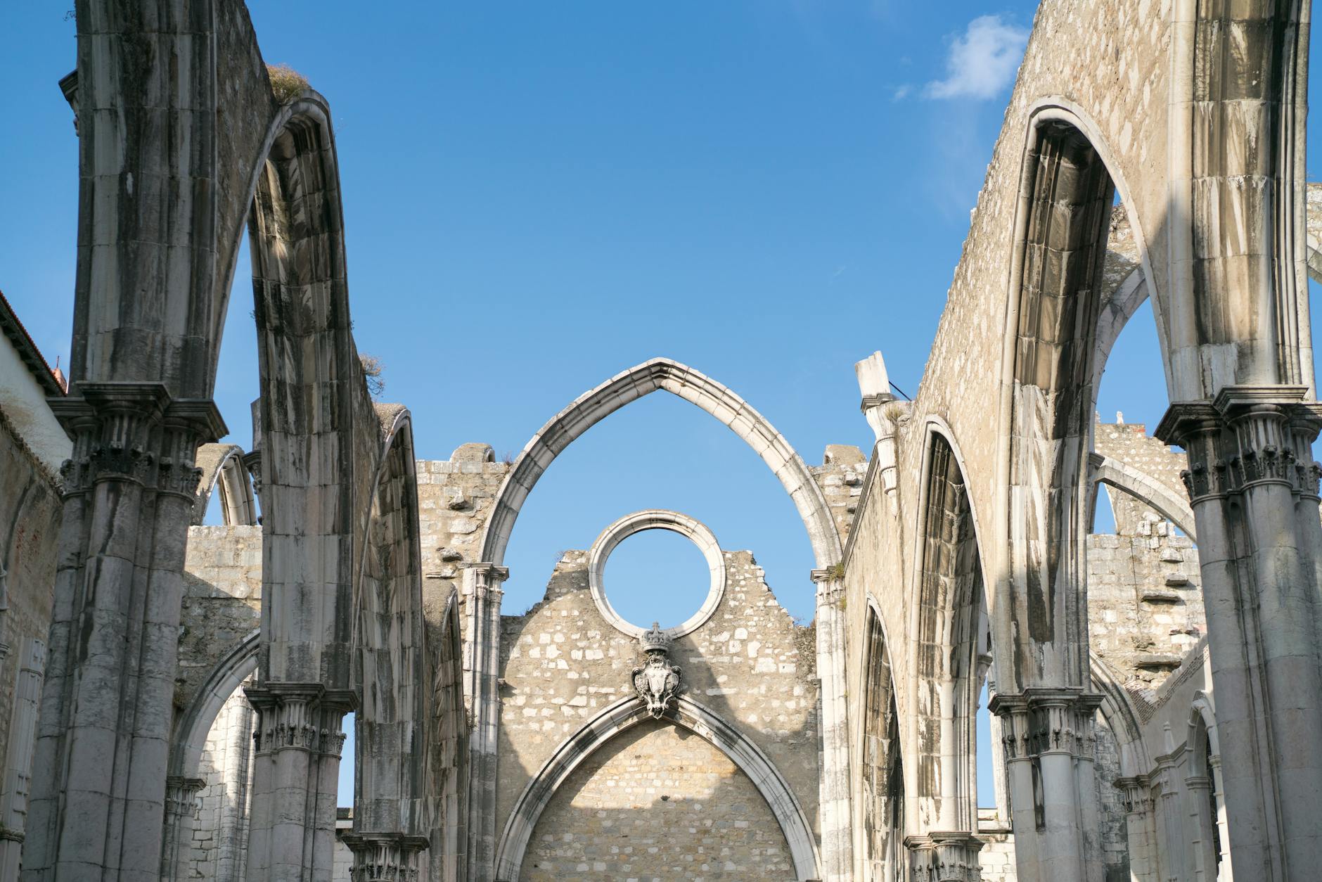
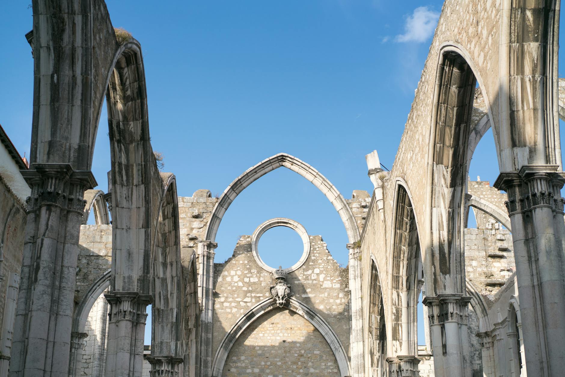
One building in Lisbon still shows the morning of 1 November 1755 as it happened. Our Carmo Convent guide covers the roofless nave the city chose never to rebuild.
The cathedral lost its Gothic choir and royal pantheon in the same morning and was rebuilt around the damage — see our Lisbon Cathedral guide for what survived and what the restorers chose to expose.
This guide tells the complete story of how the disaster shaped the Lisbon you see today. Updated for 2026.
What Happened on 1 November 1755
The date was not incidental. All Saints’ Day was one of the most important Catholic feasts of the year. Almost the entire population of Lisbon — then a city of roughly 250,000 — was in church when the first shocks arrived. Candles had been lit at altars across the city in honour of the dead. Within minutes, many of those who had gathered to pray were themselves dead.
The Earthquake: Key Facts
| Detail | What we know |
|---|---|
| Date | 1 November 1755 (All Saints’ Day) |
| Time | Around 9:40 AM local time |
| Magnitude | Estimated 7.7 or greater; some seismological studies suggest 8.5–9.0 on the moment magnitude scale |
| Epicentre | Atlantic Ocean, approximately 200 km west-southwest of Cape St. Vincent |
| Distance from Lisbon | ~290 km |
| Duration of shaking | 6–10 minutes, in three main shocks |
| Felt range | Across Western Europe and North Africa — from Finland to West Africa |
The magnitude question remains genuinely contested. Seismologists working from historical accounts estimate the moment magnitude at somewhere between 7.7 and 9.0 — a wide range that reflects the difficulty of reconstructing pre-instrumental earthquakes from written records. The lower estimate (7.7+) is the most commonly cited in academic literature; the higher estimates (8.5–9.0) come from analyses of the tsunami data. In the article, as in the historical record, both ranges are presented because no single figure has been definitively established.
The Tsunami (Around 40 Minutes Later)
Survivors who fled the collapsing buildings often made for open space near the Tagus riverfront — a sensible instinct in an earthquake. It proved fatal. Roughly 40 minutes after the first tremors, the sea receded dramatically (the classic warning sign that those 18th-century Lisboetas had no way of recognising), and then the tsunami surged inland.
- Wave height in Lisbon: Estimated ~6 metres (20 feet) along the Tagus shore
- Wave height in Cádiz, Spain: Reported up to ~20 metres (65 feet) in some locations
- Reach: The tsunami crossed the Atlantic, reaching the Caribbean, Brazil, and the coast of West Africa
- The cruelty of timing: Those who had survived the earthquake and fled to the waterfront were caught by the wave
The Fires (Six Days)
The earthquake had overturned thousands of lit All Saints’ Day candles across a city built largely of timber. Fires started in hundreds of locations simultaneously. With water supplies disrupted and rescue operations overwhelmed, the fires burned unchecked for six days.
What the earthquake had damaged structurally, the fires often finished off. The Royal Library — estimated at 70,000+ volumes including manuscripts from the Age of Discovery — burned. Most of Lisbon’s churches burned. The records of Portugal’s centuries of overseas exploration, held in the Casa da Índia, burned. Many buildings that had survived the shaking did not survive the fire.
The Death Toll
Precise figures are impossible. The disaster destroyed records along with buildings, and 18th-century population counts were unreliable even before a catastrophe. Historians present ranges, and those ranges are wide:
| Location | Estimated Deaths |
|---|---|
| Lisbon | 12,000–50,000+ (commonly cited range; some estimates higher) |
| Morocco | ~10,000 |
| Algarve region | ~5,000 |
| Total (Portugal, Spain, Morocco) | ~40,000–60,000 across the region |
Lisbon’s pre-earthquake population was roughly 250,000. The 30,000–40,000 figure most commonly cited for the city represents somewhere between 12% and 16% of the entire population. The higher estimates of 50,000+ in the city alone, used by some sources, would make it one of the single deadliest urban disasters in European history.
The honest answer is: a very large number of people died — the sources agree on that. The specific figure depends on which historical account you weight, and no consensus exists.
Buildings and Treasures Destroyed
The earthquake and fires erased much of Lisbon’s pre-18th-century built heritage. The losses were staggering:
- Royal Ribeira Palace — the Portuguese royal residence since 1500, where Praça do Comércio now stands
- Royal Library — 70,000+ volumes, manuscripts from the Age of Discovery
- Casa da Índia — royal records of overseas explorations and the spice trade
- Most of Lisbon’s churches — including major Gothic and Manueline buildings
- Hospital de Todos os Santos — Lisbon’s main hospital, killing patients inside
- ~85% of central Lisbon’s buildings in total
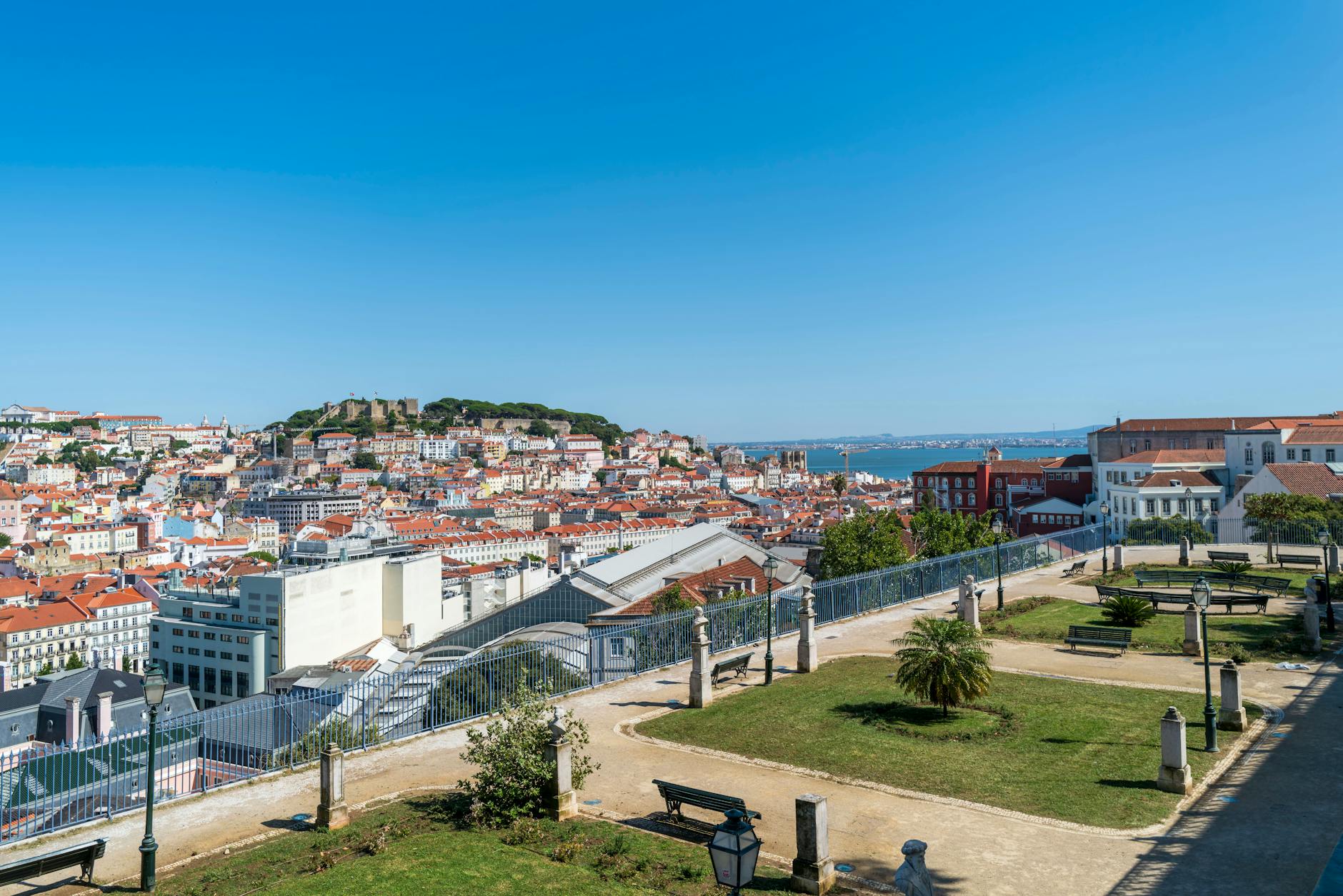
What survived: Alfama (built largely on bedrock, which dampens seismic waves — partly survived), Belém (different geological foundation, less affected), parts of Mouraria, and São Jorge Castle. These survival patterns would later inform the reconstruction plan — and explain why Alfama looks medieval today while Baixa looks 18th-century.
The Marquês de Pombal
Sebastião José de Carvalho e Melo — later elevated to the title Marquês de Pombal, and known by that name to history — was King José I’s Secretary of State (effectively prime minister). His response to the disaster was decisive enough that his name became permanently attached to the rebuilt city.
The famous anecdote: when the king asked what was to be done, Pombal reportedly answered: “Bury the dead and heal the living.” Whether the exchange happened precisely as recorded, it captured his approach. While other ministers panicked and the royal family moved into tents (the traumatised king refused to sleep inside any building for the rest of his life), Pombal acted.
Pombal’s Immediate Response
- Buried the dead at sea — rather than mass graves in the city, preventing disease spreading through the water supply
- Set up emergency field hospitals outside the city walls
- Distributed food and medicine to prevent starvation in the aftermath
- Posted soldiers to prevent looting; executed looters publicly as a deterrent
- Prevented flight — closed the city gates to stop the population leaving and the skilled labour pool disappearing permanently
- Sent the world’s first systematic earthquake survey to all Portuguese parishes, asking for descriptions of the shaking, the waves, the damage, and the timing. This questionnaire — answered by priests across Portugal — is recognised as the founding document of modern seismology.
Pombal’s Reforms (Beyond the Earthquake)
The earthquake gave Pombal the emergency powers he needed to push through reforms that had been politically impossible before. He used them:
- Banned slavery in mainland Portugal (1761)
- Expelled the Jesuits from Portugal and its empire (1759)
- Modernised commerce and broke up trade monopolies
- Reformed the tax system and public administration
- Founded the Lisbon Academy of Sciences
He was a brilliant, ruthless, and deeply controversial figure. When King José I died in 1777, Pombal was removed from power, tried, convicted of abuse of authority, and only escaped imprisonment because he was too old and ill. His legacy in the city he rebuilt, however, proved permanent.
The Reconstruction Plan
On 4 December 1755 — one month after the disaster — chief engineer Manuel da Maia presented King José I with a formal report outlining four options for Lisbon’s future:
- Rebuild as before, following the old street plan
- Repair and reinforce existing structures where possible
- Create a new city plan but on the same general footprint
- Raze the entire Baixa district and build a completely new rational grid
The king chose option 4. The result was the Pombaline reconstruction — what tourists today experience as “Baixa,” the flat downtown grid between the Tagus and Rossio Square.
What Made Pombaline Architecture Revolutionary
The new Baixa was not just a rebuilt city — it was the world’s first earthquake-resistant urban design, developed through what may be history’s earliest large-scale seismic engineering experiment. According to accounts from the time, the structural system was tested by having soldiers march in formation around scale models to simulate tremors — a crude but deliberate method for testing the design before construction.
- Wide orthogonal grid streets — straight, at right angles, designed as evacuation routes in any future earthquake, not medieval organically-grown lanes
- Standardised 4–5 storey facades — uniform height and setback across the entire district
- Iron balconies on standardised facades — aesthetic coherence across the whole grid
- The gaiola pombalina (Pombaline cage) — an internal wooden timber framework embedded within load-bearing masonry walls, designed to flex during seismic movement rather than shatter. The system dissipates energy through the lower weight and elasticity of the wood, through flexible connections between structural elements, and through the deliberate lightening of the upper stories
- First planned earthquake-resistant urban design in the world — a full century before earthquake engineering became a recognised discipline
The Earthquake’s Impact on Western Thought
The 1755 Lisbon earthquake wasn’t just a Portuguese disaster — it shook European philosophy and theology in ways that still reverberate. A devoutly Catholic city, full of churches, destroyed on the holiest day of the Catholic calendar. The churches themselves suffered as badly as secular buildings. And the red-light district of Alfama — built on bedrock, morally suspect — survived better than the sacred heart of the city. The theological implications were unavoidable.
Voltaire’s Candide (1759)
The disaster was central to Voltaire’s satirical masterpiece, published four years later. The philosopher Pangloss — a stand-in for Leibnizian optimism — preaches that everything happens for the best in “the best of all possible worlds.” The Lisbon earthquake is used by Voltaire to destroy this comfortable optimism. Candide spends the rest of the novel unlearning it, confronting a world where disasters happen to the innocent and the devout, where geography, not morality, determines who lives and who dies.
Candide is still in print, still assigned in philosophy courses, and still one of the most-read works of European literature. The earthquake made it possible.
Theological Crisis and the Enlightenment
- Why does God allow this? — A devout Catholic city, full of worshippers, destroyed on All Saints’ Day. The question was unavoidable.
- Why did the churches fare worst? — Many church buildings were more severely damaged than secular structures. (The answer is geological and structural, not theological — but the optics were damning.)
- Why did “sinful” Alfama survive? — Because it’s built on bedrock. But the observation contributed to growing scepticism about providential explanations for natural disasters.
The earthquake accelerated the Enlightenment’s challenge to the idea that God actively orchestrates earthly events to reward virtue and punish vice. It didn’t cause the Enlightenment — that was already underway — but it handed its critics their most powerful specific example.
Modern Seismology Born
Pombal’s questionnaire to all Portuguese parishes — asking the time of the shaking, the direction of movement, the types of damage, the behaviour of water in wells and fountains — was history’s first systematic earthquake survey. The responses created a dataset that 20th-century seismologists have returned to repeatedly. That questionnaire is routinely described as the founding document of scientific seismology.
What You Can See of the 1755 Earthquake Today
The earthquake’s legacy is visible everywhere in central Lisbon — once you know where to look.
Carmo Convent (Largo do Carmo)
The most powerful earthquake monument in the city. The Carmelite convent was founded in 1389 and was Lisbon’s largest Gothic church before 1755. The earthquake destroyed the roof. It was never rebuilt — a deliberate decision to preserve the ruins as they were. Today the roofless Gothic nave houses the Carmo Archaeological Museum (€7 entry), and the open arches frame the sky exactly as they have for 270 years. Evening concerts are occasionally held inside. Go.
Praça do Comércio
The great riverside square stands on the site of the Ribeira Palace — the royal residence destroyed in the earthquake. The deliberate choice to put a public commercial square here, rather than rebuild a palace, was a political statement about the new Pombaline order. See our Praça do Comércio guide.
Pombaline Baixa — the Entire Grid
Rua Augusta and its parallel streets, the regular grid from the Tagus to Rossio, the uniform building heights and iron balconies — all of it is the earthquake’s reconstruction. The flat downtown neighbourhood that tourists walk through is the result of a conscious design decision taken in December 1755. See our Baixa guide.
Lisbon Story Centre (Praça do Comércio)
A multimedia museum that walks visitors through the earthquake in detail — the event, the rescue, the reconstruction. €7 entry. A good starting point if you want context before the walking tour described below.
Núcleo Arqueológico da Rua dos Correeiros
Beneath the Millennium BCP bank building in Baixa — Roman and Phoenician remains exposed during the 1990s building renovation, plus layers of Pombaline reconstruction above them. Free with advance reservation. Not widely visited but genuinely interesting for the stratigraphy alone.
Sé Cathedral
One of the few pre-earthquake major buildings to survive in recognisable form, though damaged and partly rebuilt. The Romanesque nave dates from 1147 — older than the earthquake by 600 years. The Roman cloister below shows pre-earthquake Lisbon’s archaeological layers.
Ajuda Royal Palace (Belém)
The trauma of the earthquake left King José I sleeping in a tent for the rest of his life — he refused to sleep under a fixed roof again. When his successor decided to build a new royal residence, the site chosen was Ajuda in Belém, away from the earthquake zone. Construction began in 1796. The palace treasury, opened in 2022, houses collections that survived only because they weren’t in Lisbon on 1 November 1755.
Belém Tower
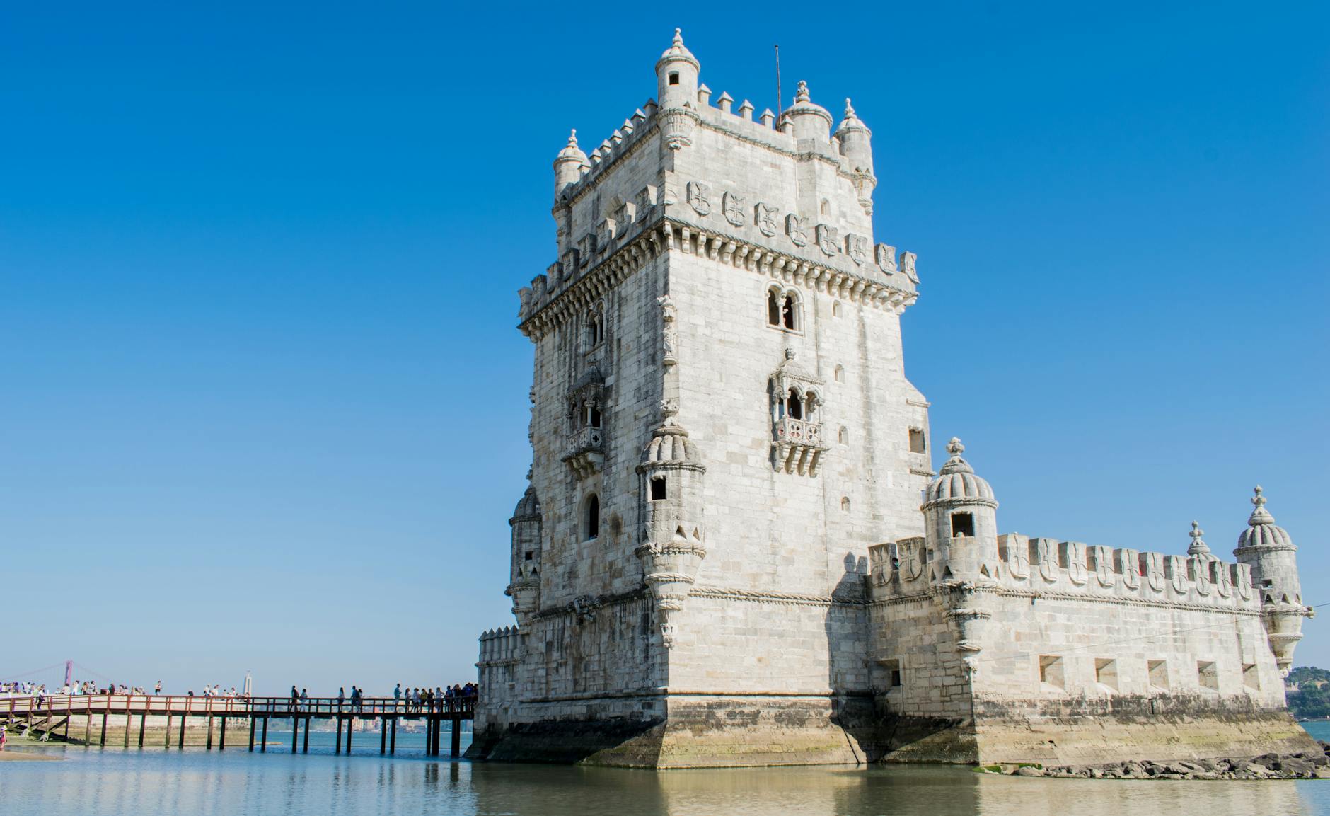
Built between 1516 and 1521, the Belém Tower survived the 1755 earthquake — one of the relatively few major Manueline monuments that did. Its geological position (on a different substrate from the Baixa floodplain) and solid stone construction helped. It stands as a pre-earthquake survivor in a city otherwise rebuilt from scratch. See the UNESCO World Heritage listing for both the Tower and the Jerónimos Monastery.
Why Some Buildings Survived and Others Didn’t
Geology Was Everything
The pattern of destruction followed the underlying geology with remarkable consistency. Buildings on solid bedrock fared far better than those on the soft alluvial river deposits that filled the Baixa valley. This was not obvious to people at the time — they saw the moral geography of the city (the religious centre destroyed, the red-light district partially spared) not the geological one. But it is the explanation.
- Alfama — built on bedrock, earthquake amplification lower, mostly survived
- Belém — different geological substrate, less shaking, less damaged
- Baixa — river floodplain alluvium, maximum amplification of seismic waves, maximum destruction
Tsunami Reach Was Selective
The tsunami only reached the low-lying Tagus-side neighbourhoods. Hilltop districts like Bairro Alto and Graça were tsunami-immune regardless of their proximity to the river.
Fire Was Random
Where the fires went depended on wind direction, luck, and which buildings happened to have overturned candles in which rooms. Some structurally intact buildings burned; some already-damaged ones survived the fire. The six-day duration made the damage almost impossible to fight.
Lessons for Modern Lisbon
The Seismic Risk Remains
Lisbon sits on the boundary between the Eurasian and African tectonic plates. The fault system that produced the 1755 earthquake still exists. Modern seismologists consider Lisbon one of Europe’s most seismically exposed capital cities. The Portuguese Institute for Sea and Atmosphere (IPMA) monitors seismic activity continuously. Building codes across Portugal require seismic resilience.
A major earthquake of similar scale within the next few centuries is considered geologically probable — though predicting earthquakes precisely remains beyond current science.
For Travellers Visiting Today
- The flat downtown grid you walk through is the earthquake’s legacy — designed as an evacuation route
- Alfama’s narrow medieval streets exist because they survived the quake; Baixa’s wide straight streets exist because they were built after it
- Praça do Comércio replaced a royal palace — the political statement is still legible 270 years later
- Many “ancient” Lisbon buildings are actually 18th-century reconstructions built to look older — the Pombaline style was deliberately classicised
- The National Tile Museum holds an 18th-century panoramic azulejo panel showing Lisbon before the earthquake — the only detailed visual record of the lost city. See our tile museum guide.
Earthquake Walking Tour (Self-Guided)
Allow 3–4 hours. Start at the Lisbon Story Centre for context, then walk the geography of destruction and survival:
- Start: Praça do Comércio — stand where the royal palace stood until 9:40 AM on 1 November 1755
- Walk north up Rua Augusta — you’re walking through the earthquake’s reconstruction, built from zero in 1756–1775
- Rossio Square (rebuilt post-quake) — the commercial and social centre of the new Pombaline city
- Walk west to Largo do Carmo — see the Carmo Convent’s roofless Gothic ruins. This is the heart of the itinerary.
- East to Sé Cathedral — pre-earthquake survivor, built 1147, damaged 1755, still standing
- Up into Alfama — walk the medieval streets that survived because they’re on bedrock
- Optional end: Lisbon Story Centre (or start there for context)
Other Earthquake Sites in Portugal
- Faro (Algarve) — Damaged and rebuilt; some pre-quake buildings survive in the old town
- Santarém — Less severely affected; medieval features intact
- Setúbal — Hit by both earthquake and tsunami; rebuilt in the Pombaline period
Books and Films
Books
- Wrath of God by Edward Paice — The definitive English-language account of the earthquake, its causes, and its consequences
- The Enlightenment’s Fable edited by Theodore E. D. Braun & John B. Radner — Interdisciplinary essays on the earthquake’s cultural and intellectual impact
- Candide by Voltaire — The literary response; still the most widely read text to emerge from the disaster
Films and Documentaries
- Portuguese animated film 1755 (2015) — accessible dramatisation
- Various Portuguese-language documentaries available via RTP archives
FAQ: 1755 Lisbon Earthquake
What was the magnitude of the 1755 Lisbon earthquake?
Seismologists estimate 7.7 or greater on the moment magnitude scale, with some analyses suggesting 8.5–9.0. The epicentre was in the Atlantic Ocean approximately 200 km west-southwest of Cape St. Vincent. The wide range reflects the difficulty of reconstructing pre-instrumental earthquakes from historical accounts alone.
How many people died in the 1755 Lisbon earthquake?
Historians present a wide range: 12,000 to 50,000+ in Lisbon, depending on the source. The commonly cited figure is 30,000–40,000 for the city. Total deaths across Portugal, Spain, and Morocco are estimated at 40,000–60,000. Precise figures are impossible — the disaster destroyed records along with buildings.
Did anything survive the 1755 earthquake?
Yes. Alfama survived largely intact due to its bedrock foundation. Belém was less severely affected. Sé Cathedral survived in damaged form. São Jorge Castle survived. The Belém Tower survived. The pattern follows geology almost exactly — bedrock good, river alluvium catastrophic.
What rebuilt Lisbon?
The Marquês de Pombal commissioned a new urban plan from chief engineer Manuel da Maia. The king chose the most radical option: raze the Baixa entirely and build a new earthquake-resistant grid. Construction ran from roughly 1756 to 1775. The result — the Pombaline Baixa — still defines central Lisbon.
Why is Carmo Convent in ruins?
The 14th-century convent was destroyed in the 1755 earthquake and never rebuilt. The decision to leave the roofless Gothic ruins as they were was deliberate — a memorial. The open nave now houses the Carmo Archaeological Museum and functions as one of Lisbon’s most evocative spaces.
Could Lisbon have another major earthquake?
Yes — Lisbon sits on the Eurasian-African tectonic plate boundary, the same fault system that caused the 1755 event. Modern building codes account for seismic risk. Major earthquakes are statistically rare on any given human timescale but geologically expected over centuries. Tsunami warning systems exist for the Atlantic coast.
Bottom Line
The 1755 Lisbon earthquake shaped not just the city’s physical layout but Western thought, urban planning philosophy, and the science of seismology. Walk Praça do Comércio knowing a royal palace once stood there. Stand in Carmo Convent’s roofless nave and look up through the Gothic arches at open sky. Walk the straight streets of Baixa and understand that every metre of that grid was a deliberate response to catastrophe. The disaster’s legacy is everywhere in Lisbon — once you know what to look for, you can’t unsee it.
The physical evidence is spread across the city’s collections. The National Tile Museum holds the great panorama of Lisbon as it stood before 1755, the Gulbenkian and MAAT pick the story up from opposite ends of the centuries that followed, and the Museums & Culture guide covers what else came through.